Accessing OpenStreetMap
From University Map Wiki
Jump to navigationJump to search
Using University map tiles as a background layer in JOSM
To include the University map as a background layer in JOSM, the OSM desktop editor, do the following (just once on each computer where you use JOSM):
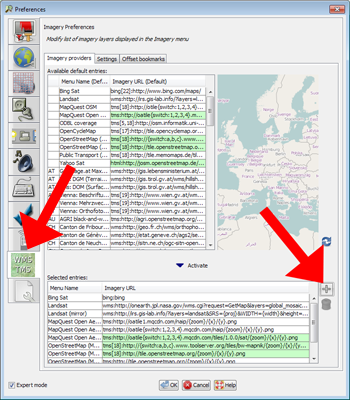
- Go to Edit > Preferences
- Click the WMS/TMS icon (second from bottom at time of writing)
- In the bottom section, press the + button to the right of the Selected Entries panel:

- In the dialog that pops up, switch to the TMS tab
- In the Menu Name box right at the top, replace "Unnamed Imagery Layer" with "University of Cambridge"
- Copy and paste the following verbatim into the Imagery URL box at the bottom (NOT the "service URL" box near the top, which you should leave alone):
tms[19]:http://map.cam.ac.uk/tiles/{zoom}/{x}/{y}.png


- Click OK on each to save and exit the two dialogs.
The setting will then be remembered permanently.
To turn on the layer
Then, whenever you use JOSM you can include this layer by choosing "University of Cambridge" from the Imagery Menu. It will behave like any other image layer, so
- you can combine it with the translucency controls (bottom of the layers control panel)
- you can toggle it on and off using the little eye symbol next to the layer name in the layers panel
- but, because tiles are only available for zoom 13 and above, and in the Cambridge area, you'll get messages in place of tiles that don't exist
There is currently about a 2m offset from the data in the y (latitudinal) direction. I'm not sure exactly why, but I am investigating.