Case Studies: Difference between revisions
(Typos fixed.) |
|||
| (One intermediate revision by one other user not shown) | |||
| Line 17: | Line 17: | ||
==Planning Application== | ==Planning Application== | ||
The 'Design and Access Statement' for [http://idox.cambridge.gov.uk/online-applications/applicationDetails.do?activeTab=documents&keyVal=MSPATQDX07800 planning permission request 13/1326/FUL at 1 Milton Road] uses a screen | The 'Design and Access Statement' for [http://idox.cambridge.gov.uk/online-applications/applicationDetails.do?activeTab=documents&keyVal=MSPATQDX07800 planning permission request 13/1326/FUL at 1 Milton Road] uses a screen grab of the University Map to show the site in its wider context and its relationship with University 'campuses'. | ||
==Network Infrastructure planing== | ==Network Infrastructure planing== | ||
| Line 28: | Line 28: | ||
There's also [https://www.wireless.cam.ac.uk/city/ an on-line presentation of this map], complete with statistical overlay (see the menu top-right). | There's also [https://www.wireless.cam.ac.uk/city/ an on-line presentation of this map], complete with statistical overlay (see the menu top-right). | ||
==Graduate Admissions== | |||
As part of a national effort to improve provision of information on Post-graduate Taught courses, the University will be publishing an [http://xcri.co.uk XCRI-CAP] feed for consumption by multiple aggregators including [http://www.prospects.ac.uk Prospects]. This feed uses department location data aggregated from the public map API to form part of the mandatory set of information required by the specification. | |||
Additionally, the 2016 Graduate Prospectus will use the public map API to supplement data already held on departments and colleges for applicants; both embedding a map for each institution and providing contact details. | |||
Latest revision as of 12:52, 6 February 2015
If you are using the map (especially if you are doing something innovative with it) them please mention it here.
Official Cambridge iPhone App
The Official Cambridge iPhone App, developed by the Office of external Affairs and Communications, uses the University's map tiles rather than generic OpenStreetMap ones.
CamExplore
The CamExplor, a desktop and mobile site suporting the University's 2013 Open Days, uses copies of the University's map tiles.
Alumni Festival
The 2013 Alumni Festival used a screen grab of and link to the map to locate their Welcome Centre in the Alison Richards building.
Planning Application
The 'Design and Access Statement' for planning permission request 13/1326/FUL at 1 Milton Road uses a screen grab of the University Map to show the site in its wider context and its relationship with University 'campuses'.
Network Infrastructure planing
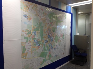
A large print version of the map, being used to plan computer network infrastructure in support of 2014 Tour de France visit to Cambridge.
Tour de France network coverage map
The University Map was used (unfortunatly without any acknowledgements) as a background for a network coverage map in a Cambridge News article about the Tour de France public Wifi.
There's also an on-line presentation of this map, complete with statistical overlay (see the menu top-right).
Graduate Admissions
As part of a national effort to improve provision of information on Post-graduate Taught courses, the University will be publishing an XCRI-CAP feed for consumption by multiple aggregators including Prospects. This feed uses department location data aggregated from the public map API to form part of the mandatory set of information required by the specification.
Additionally, the 2016 Graduate Prospectus will use the public map API to supplement data already held on departments and colleges for applicants; both embedding a map for each institution and providing contact details.
