West Cambridge
Outline Planning Application October 2017 revisions
University of Cambridge has released new revisions to the 16/1134/OUT planning application for the West Cambridge site. The documents are rather long so we have looked through the documents, extracted relevant sections, and made notes on objectionable things.
This is the time to object and get things changed. The more time passes the more difficult it will be. Unfortunately the Cavendish III planning application is moving ahead faster than the outline planning application, even though they both impact heavily on JJ Thomson Ave and Madingley Road. Both applications have problematic designs for these roads. But once Cavendish III is approved and begins construction, it will commit the University to building many of these mistakes in the outline planning application, even though the outline planning application is still undecided.
Executive Summary
The previous version of the outline planning application had segregated cycleways. Many of these have been removed from this version of the plan. On-site cycling provision will be on-road mixed with motor vehicles for JJ Thomson Ave, Charles Babbage Road and Ada Lovelace Road. JJ Thomson Ave may have some shared-use paths but they will have the same problems as today.
Charles Babbage Road and JJ Thomson Ave will host at least 9 buses per hour in each direction, as well as various shapes and sizes of delivery vehicles. This violates the sustainable safety principle of separating human beings from moving heavy vehicles. Also, there does not appear to be any significant form of traffic calming mechanism because vertical measures cause vibrations that may disturb physics experiments. At junctions, the proposed ‘shared-surface’ crossings are not actually shared surfaces, they are split-level with dropped kerbs: no different than any other motorist-priority crossing except for having fancier paving slabs.
Off-road routes such as ‘The Green’ may offer some additional routes in the future, if and when they are completed, but there are conflicting goals for this route. It will be a ‘shared-use path’ and there is at least one reference that claims ‘The Green’ is for ‘slow-moving cycling’. This is unclear and seems to denigrate the use of ‘The Green’ as a main cycle route, capable of carrying tens of thousands of people cycling per day as expected in full build. Therefore that leaves Charles Babbage Road to handle the load, with no dedicated cycling facilities and mixing people cycling with heavy and long vehicles, which can only lead to problems.
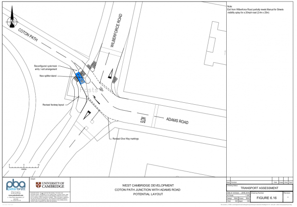
Off-site proposed improvements range from ineffective to outrageous, and in some cases the proposals seem to completely forget the existence of people walking and cycling. There is one good proposal, which is the Coton Path / Adams Road junction finally getting fixed to be suitable for the amount of cycling traffic it handles.
These design proposals for JJ Thomson Ave, Charles Babbage Road, etc are in contradiction to the 2021 Transport Strategy, which calls for ‘segregated cycle tracks’ on site roads.
Relevant extracts with notes as well as the original revised planning application PDFs (combined and compressed for convenience):
- Design Guidelines [Relevant extracts with notes] Full document
- Design and Access Statement [Relevant extracts with notes] Full document
- West Cambridge Masterplan Full document
- Transport Assessment [Relevant extracts with notes] Full document
- Travel Plan Full document
- Shared Facilities Hub & Cavendish III
- Cavendish III is now submitted as city planning application 17/1799/FUL and since it involves rebuilding JJ Thomson Ave it incorporates many of the same problems as the overall outline planning application. (October 2017)
- (old) Consultation boards posted here: File:University of Cambridge Shared Facilities Hub Cavendish III Exhibition.pdf
Community Forum Minutes
- 2017-03-21 West Cambridge Community Group minutes: File:170321 wccg mins final.pdf
Planning Documents (2016 version)
- File:CUED Civil Engineering Planning Boards 170522 final.pptx Updated (004).pdf Civil Engineering Building to commence 5th June 2017
- 16/1134/OUT Official website showing outline planning permission for new developments at West Cambridge Site.
Design Guidelines (2016 version)
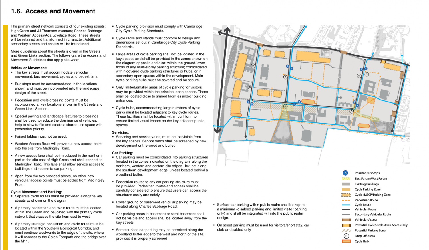
Planned access and movement map:
JJ Thomson Ave redesign conceptual view: See also: Cross-section of High Cross showing pavements, cycle lanes, trees and carriageway.
- Part 3: File:16 1134 OUT-DESIGN GUIDELINES PART3-1963107.pdf
- Part 4: File:16 1134 OUT-DESIGN GUIDELINES PART4-1963109.pdf
Transport Assessment (2016 version)
- Part 1: File:16 1134 OUT-TRANSPORT ASSESSMENT PART1-2090515.pdf (main document)
Access and movement strategy (starting on pg 50). Selected quotes:
- 6.5.13 To maintain their attractiveness, the proposed with-flow segregated Cycle tracks along the main routes through West Cambridge must be continuous and as such retain priority over side road junctions and vehicular accesses to plots. To achieve this, the priority along the Cycle track would be clearly identified when crossing the side road - this would also serve to slow on-site vehicle speeds.
- 6.5.15 The strategy outlined above provides only a limited number of routes that require cyclists to be on-road: these are confined to quiet none-through routes.
- 6.5.16 The ‘with-traffic’ provision on the main routes will have a segregated provision either adjacent to the road (e.g. the Western Access Road) or adjacent to the footway (e.g. Charles Babbage Road, High Cross, JJ Thomson Avenue).
- 6.5.17 As new on-site infrastructure is delivered, cyclists would be provided with continuous routes, with priority over side road movements.
- 6.8.12 As discussed and agreed with the Joint Authorities, the University would contribute towards the costs of this existing on-road car parking being removed from both sides of the carriageway, and being replaced with two mandatory cycle lanes. This would provide significant betterment for residents and cyclists, and improve the quality of the public realm on [Clerk Maxwell Road].
- 6.9.5 To enhance Walking and Cycling, the University would make contributions towards the delivery of the following improvements to the existing Coton Path route, reflecting the concerns of the West and North West Cambridge Cycling Group, and the Cambridge Cycling Campaign:
- as shown on Figure 6.1, at the western end of West Cambridge, a new Cycle and Pedestrian route will be provided between the M11 bridge crossing and the Western Access Road within West Cambridge. This will reduce the distance between these two points by approximately 250 metres, providing better access to locations within West Cambridge;
- the Coton Path will be widened within the boundary of the West Cambridge site, where achievable, to improve connections to the east;
- improved connections to Coton Path will be redesigned to improve the layout for pedestrians and cyclists accessing West Cambridge. The key connections to be improved include those at the end of Clark Maxwell Road), the Cavendish Laboratory areas and that to the east of the Hauser Forum Building. The Cavendish Laboratory access would provide a new access to Coton Path that gives cyclists an alternative route between the existing Hauser Forum and Broers Building which can then become pedestrian only;
- as suggested by the Cambridge Cycle Campaign, maintenance to the existing vegetation that currently reduces the effective width of this route constraining forward visibility;
- the route would be realigned where possible to remove the sharp turns along Coton Path directly to the south of West Cambridge; and the eastern terminus of the Coton Path – the junction with Wilberforce Road and Adams Road – will be redesigned providing a more direct and continuous route for Cyclists while also slowing passing vehicles – thus prioritising Cycle movements. Details are shown on Figure 6.16.
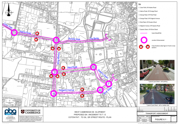
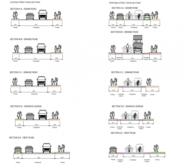
- 6.9.8 As shown on Figure 6.15(a), it is proposed that a Cycle Street environment could be created along Adams Road. As part of this, the University will contribute to the necessary traffic regulation orders to rationalise parking to provide more road space for Cycling.
- 6.10.4 As shown on Figure 6.15(b), a new, fast and high-capacity Cycle route could be created between the Grange Road / Adams Road junction and the City Centre – this will be an attractive signed alternative route to the relatively limited Cycle capacity offered by Burrell’s Walk, thus controlling the existing and future number of movements along this route. This proposed route will follow the Grange Road – Sidgwick Avenue – Silver Street corridor
- 7.4.2 Citi 4 - for the Initial Phase of development, to be revised to divert from a section of Madingley Road via High Cross to JJ Thomson Avenue, to operate within the West Cambridge Development;
- 7.4.3 Western Orbital operation of a new hourly service from West Cambridge via North West Cambridge, NIAB and the Science Park to Chesterton station (subject to the NIAB Development delivering the through-route from Huntingdon Road to Histon Road) [NB: this may be out of date, City Deal is proposing a much more frequent service];
Possible responses
Ideas for responses we could provide.
Daniel Thomas
Provisions for Adams Road, Grange Road, Sidgwick Avenue and West Road are insufficient. To provide sufficient capacity:
- Parking should be removed from Adams Road and mandatory cycle lanes placed down both sides (in the same style as used on Huntington Road).
- Grange Road should be closed to through traffic (for example by congestion control points provided by having cameras at each end of the road that then trigger if both observe the same number plate).
- Sidgwick Avenue should be made one way (except cycles) heading west with mandatory cycle lanes placed down both sides and a floating bus stop.
- West Road should be made one way (except cycles) heading east with mandatory cycle lanes placed down both sides and a floating bus stop.
- The off-road cycle path on the west side of Queens Road north of West Road should be improved in quality and properly signed.
- Some sort of dedicated cycling provision should be provided on the west side of the section of Queens Road between Sidgwick Avenue and West Road.
- The footpaths on the east side of Queens Road should be improved so that cycling provision can be provided, not just on the Queens' Green section but at least all the way up to Garret Hostel Lane.
The advantage of this one way system on Sigwick Avenue and West Road is that substantial bus traffic and cycle traffic can be simultaneously supported on the roads as busses will never meet a bus heading in the opposite direction while on a road too narrow for them to pass safely without making use of the cycle lane. The disadvantage is that the bus stops on West Road and Sigwick Avenue will be on the opposite side of the road to the Sigwick site and so most bus travellers will need to cross the road. The westbound bus stop is also further from the University Library. The advantage of this direction choice is that it minimises overlap of the busses on Grange Road, particularly if the second guided busway goes ahead and uses Adams Road for into town traffic and Cramner Road for out of town traffic (my preference if such a busway were to be built, not sure such a busway is necessary).


